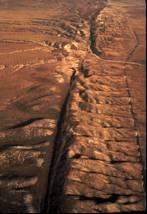
The image is an aerial photograph. what is the geological feature shown?
a) a large fault on...

Geography, 22.09.2019 08:10 SpittingFatLama
The image is an aerial photograph. what is the geological feature shown?
a) a large fault on earth’s crust
b) the dry bed of an ancient river
c) a canyon, created by the erosion
d) sand dunes deposited by the wind

Answers: 1
Another question on Geography
Geography, 22.06.2019 03:30
Japan is a group of four islands off the coast of asia. what effect do you think has had on the lives of the japanese?
Answers: 1
Geography, 23.06.2019 14:00
Is a state government creates a new tax to fund schools a example of checks and balances
Answers: 1
Geography, 23.06.2019 19:30
This is a 2017 topographic map of puerto rico in the united states, and i'm sorry that people there have suffered such a disaster. i want to ask, what do the yellow dots and areas represent on this graph? and the blue area and the little blue circle, and the little blue sign that looks like a signal tower, what do they stand for?
Answers: 2
Geography, 24.06.2019 00:40
Which event most likely explains renewed demand in a recovery period? consumers choose to save more and spend less. economic policy renews consumer confidence and demand. producers decrease prices to prompt demand and recovery. production decreases to prompt increased demand.
Answers: 2
You know the right answer?
Questions

Mathematics, 20.01.2022 19:00
Mathematics, 20.01.2022 19:00
Mathematics, 20.01.2022 19:00


Computers and Technology, 20.01.2022 19:10

Biology, 20.01.2022 19:10

Mathematics, 20.01.2022 19:10


