WILL GIVE BRAINLIEST!
DAIRY FARMS IN THE UNITED STATES
Source: United States Department of Ag...

Geography, 12.10.2020 20:01 Suheily218
WILL GIVE BRAINLIEST!
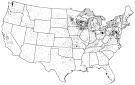
DAIRY FARMS IN THE UNITED STATES
Source: United States Department of Agriculture, Census of Agriculture, 2012
The map shows the distribution of dairy farms across the Lower 48 of the United States. Each dot on the map represents approximately ten dairy farms.
A. Identify ONE type of boundary data shown on the map.
B. Identify the region of the United States where most dairy farms are located.
C. Identify ONE spatial pattern shown on the map.
D. Describe the characteristic land use associated with the spatial pattern shown on the map.
E. Describe TWO geographic features not shown on the map that would help explain the patterns of dairy farming shown on the map.

Answers: 1
Another question on Geography
Geography, 22.06.2019 18:30
Which statement best explains distribution of natural resources? people tend to settle in locations that have the resources they need for survival. some countries have resources that others lack, so trade between countries becomes vital. fossil fuels come from areas that have mountains and other areas that manufacture synthetic gas. areas with natural resources provide a higher standard of living and better quality of life.
Answers: 3
Geography, 23.06.2019 15:20
Which of these is the sound of fish slapping against human flesh?
Answers: 1
You know the right answer?
Questions


Mathematics, 15.07.2020 01:01

Biology, 15.07.2020 01:01
Mathematics, 15.07.2020 01:01

Mathematics, 15.07.2020 01:01

Health, 15.07.2020 01:01
Mathematics, 15.07.2020 01:01

Social Studies, 15.07.2020 01:01

Mathematics, 15.07.2020 01:01


