
VERY EASY!!Use Microsoft word
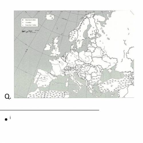
Use BLACK INK and the corresponding numbers to label the following European landforms. You can look on the internet for guidance. Color according to the type of landform listed below. When you have finished labeling and coloring all landforms, color the remaining land yellow.
*Remember: There should be no white areas on your map.*
Bodies of Water: Blue
1.Adriatic Sea
2.Atlantic Ocean
3.Baltic Sea
4.Black Sea
5.English Channel
6.Mediterranean Sea
7.North Sea
8.Strait of Gibraltar
Peninsulas: Green
9.Balkan
10.Iberian
11.Italian
12.Jutland
13.Scandinavian
Mountain Ranges: Brown
14.Alps
15.Apennines
16.Balkans
17.Pyrenees
18.Urals
Rivers: Red
19.Danube
20.Rhine
21.Seine
22.Thames
Other: Purple
23.Northern European Plain
24.Black Forest
European Political Features
Use BLACK INK and the corresponding letters to label the following cities and countries. Write the names of each country’s capital ONLY where it is requested.
A. Austria
B. Belgium
C. Czech Republic
D. England CAPITAL:
E. France CAPITAL:
F. Germany CAPITAL:
G. Ireland
H. Italy CAPITAL:
I. Netherlands
J. Poland
K. Portugal
L. Romania
M. Slovakia
N. Spain CAPITAL:
O. Sweden
P. Switzerland

Answers: 1
Another question on Geography
Geography, 22.06.2019 08:50
Eastern europe’s population growth can be attributed to these factors. select all that apply migration
Answers: 2
Geography, 23.06.2019 01:30
Why would the composition of a meteorite resemble the earth's interior?
Answers: 1
Geography, 23.06.2019 15:10
Which of the following lists shows the events in the correct order? a.)the creation of the british raj, the sepoy rebellion, gandhi’s campaign of civil disobedience, the partitioning of indiab.) gandhi’s campaign of civil disobedience, the sepoy rebellion, the creation of the british raj, the partitioning of indiac.)the sepoy rebellion, the creation of the british raj, gandhi’s campaign of civil disobedience, the partitioning of indiad.)gandhi’s campaign of civil disobedience, the creation of the british raj, the partitioning of india, the sepoy rebellion
Answers: 1
Geography, 23.06.2019 19:50
Select the correct answer.look at this nineteenth-century illustration of london. which explanation best relates this illustration to changes in britain in the 1800s? a.factory workers in cities lost their livelihood because of the lack of housingb.industrialization narrowed the inccome gap between landowners and workers.c.the migration of workers from rural to urban areas resulted in overcrowded citiesd.the spread of railways allowed farmers to sell produce far from where it was grown.
Answers: 1
You know the right answer?
VERY EASY!!Use Microsoft word
Use BLACK INK and the corresponding numbers to label the following Eu...
Questions


English, 24.09.2019 00:30

Geography, 24.09.2019 00:30


