
Geography, 16.12.2020 17:10 kris22elizondop9v1bb
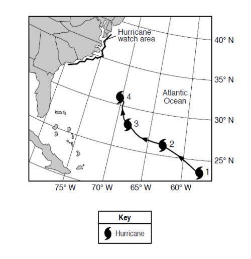
Base your answer to question 1on the map below and on your knowledge of science. The map shows the partial storm track of a hurricane and the hurricane watch area where it is predicted to reach land. Numbers 1 through 4 show positions of the hurricane on four different days at 12 noon.
Why was a hurricane watch posted for the coastal areas shown?
A To tell people where the hurricane started.
B To encourage residents to travel to the watch area.
c To warn people of life-threatening conditions.
d To alert residents of climate changes.

Answers: 2
Another question on Geography
Geography, 21.06.2019 14:00
In august 2012, tropical storm isaac formed in the caribbean and was headed for the gulf of mexico. there was an initial probability of .69 that isaac would become a hurricane by the time it reached the gulf of mexico (national hurricane center website, august 21, 2012). what was the probability that isaac would not become a hurricane but remain a tropical storm when it reached the gulf of mexico?
Answers: 3
Geography, 22.06.2019 23:00
Trade routes emerged along which coast when arab and indian traders from around the indian ocean mixed with the bantu people from africa's interior? a. swahili coast b. guinea coast c. drakensberg coast d. namib coast
Answers: 2
Geography, 24.06.2019 09:30
Why did the first fleet take the shorter route along the entire west coast of africa?
Answers: 1
Geography, 24.06.2019 20:00
The mississippi river is __ of washington, dc. north south east west
Answers: 2
You know the right answer?
Base your answer to question 1on the map below and on your knowledge of science. The map shows the p...
Questions

Physics, 25.06.2019 04:50
Physics, 25.06.2019 04:50


History, 25.06.2019 04:50

Biology, 25.06.2019 04:50
Mathematics, 25.06.2019 04:50
History, 25.06.2019 04:50
Biology, 25.06.2019 04:50

English, 25.06.2019 04:50

Biology, 25.06.2019 05:00

Social Studies, 25.06.2019 05:00
Biology, 25.06.2019 05:00


