
Geography, 30.01.2021 03:00 leahmitch612
(07.01, 07.02, 07.04, 07.07 HC)
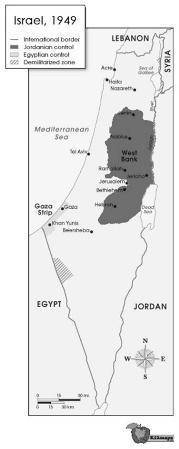
Map image showing Israeli borders and armistice lines in 1949. The map shows the state of Israel, which is bordered to the north by Lebanon, to the east by Syria and Jordan, to the south by Egypt, and to the west by Egypt and the Mediterranean Sea. The map shows that an area called the West Bank is controlled by Jordan and located in northeastern Israel. An area called the Gaza Strip is controlled by Egypt and located in western Israel along the border with the Mediterranean Sea.
© 2011 The Exploration Company
1. Discuss the evolution of the nation-state concept.
2. Based on your answer to Part A, discuss why the region shown in this map has proven so volatile. Identify at least TWO peoples who have competed to control this land, and explain why conflict over the control of territory in the above region has led to acts of terrorism.
3. Study the map above. Then answer the following questions:
a. Identify ONE type of political boundary shown on the map.
b. Explain the significance of this boundary today.

Answers: 2
Another question on Geography
Geography, 23.06.2019 18:00
In upholding louisiana's separate car act, the supreme court claimed thatsegregation was not the same as discriminationthe fourteenth amendment did not apply to southern statesdiscrimination was necessary in order to maintain public ordero segregation was unconstitutional based on the fourteenth amendment
Answers: 3
Geography, 24.06.2019 07:00
What empire controlled most of the middle east except for a few years between 1516 and 1917, where was the capital of this empire located and what was the geographic extent of this empire?
Answers: 1
You know the right answer?
(07.01, 07.02, 07.04, 07.07 HC)
Map image showing Israeli borders and armistice lines in 1949. The...
Questions

Mathematics, 01.04.2020 20:42

English, 01.04.2020 20:43


History, 01.04.2020 20:43

Mathematics, 01.04.2020 20:43


English, 01.04.2020 20:43
Mathematics, 01.04.2020 20:43


