
Geography, 10.03.2021 01:00 pheonixhowls
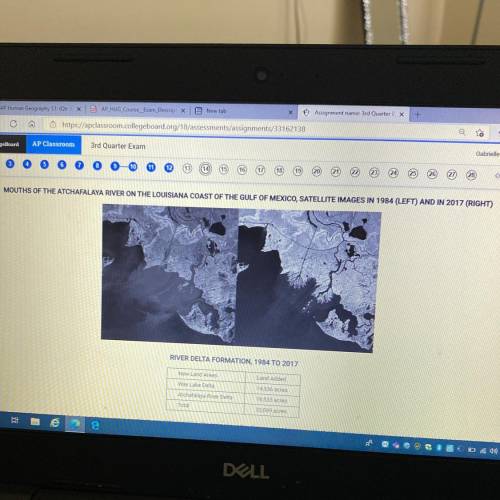
The satellite images show changes to a portion of the Louisiana coast between 1984 and 2017. The table shows the changes in land acreage. Which of the following best describes the changes
and a consequence of the changes?
A )The expansion of coastal cities, which results in increased acreage of urban land cover
B) A decrease in the acreage of coastal land,
which affects the prices of local property
c )An increase in the acreage of coastal land, which will be added to navigational charts for shipping
D )The rise of sea levels, which results in decreased land acreage available for homes and businesses
E )An increase in land acreage caused by the construction of polders for land reclamation

Answers: 3
Another question on Geography
Geography, 22.06.2019 09:30
Amountain created from tectonic activity would be considered which type of landform ? a) primary landform b) secondary landform
Answers: 2
Geography, 22.06.2019 18:00
Which of the following is defined as combinations of soil particles that vary in size and shape?
Answers: 3
Geography, 23.06.2019 20:20
Ano anu ang mga guhit na makikita sa mapa o globo? ibigay ang kuhulugan ng bawat isa
Answers: 2
You know the right answer?
The satellite images show changes to a portion of the Louisiana coast between 1984 and 2017. The tab...
Questions


Biology, 07.10.2019 22:00

Social Studies, 07.10.2019 22:00

Physics, 07.10.2019 22:00

History, 07.10.2019 22:00
Social Studies, 07.10.2019 22:00
English, 07.10.2019 22:00


Computers and Technology, 07.10.2019 22:00


