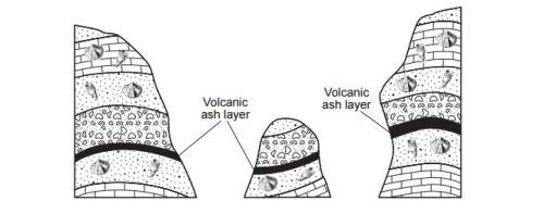
The cross sections below represent three bedrock outcrops found several kilometers apart.
whic...

Geography, 25.08.2019 11:50 kenleighbrooke67
The cross sections below represent three bedrock outcrops found several kilometers apart.
which statement best explains why the volcanic ash layers are useful for correlating the relative ages of the
bedrock in the three outcrops?
(1) the ash was deposited over a large area when a volcano erupted.
(2) there are no fossils found within the volcanic ash.
(3) the volcanic eruptions that produced the ash layer occurred over a long period of geologic time.
(4) the volcanic ash is found between many different layers of bedrock.

Answers: 1
Another question on Geography
Geography, 22.06.2019 16:00
Where does the availability of water pose the greatest problem
Answers: 1
Geography, 23.06.2019 21:40
Directions you probably already know that people have different ways to organize their ideas. some people make lists or outlines, some draw pictures, while others may combine these two methods. experiment with different note-taking techniques to find the one which works best for you. one common note-taking technique is webbing. webbing uses the sizes of circles to indicate the importance of items. lines are used to indicate the relationships between items. the example below is based on the information presented in a previous lesson. notice that the circle for "geography is" appears at the center of the web. it has larger than the circles that surround it. the "geography " circle is surrounded by smaller circles of earth's atmosphere, earth's climate, earth's surface. notice the lines that connect these items to the concept of geography. notice that the circles surrounding atmosphere are smaller. also observe that the lines that connect the items and indicate the relationships between the items. webbing will you capture the most important points in your lessons. beginning with lesson two, geographic tools: globes and maps, use webbing to take notes on the important information in this unit. hint: it will be easier to complete this project if you take your notes after completing each lesson.
Answers: 1
Geography, 24.06.2019 04:20
Liquefaction is a. a quicksand-like condition arising in some wet soils during earthquakes. b. flooding caused by tsunamis. c. flooding of coastal areas due to tectonic subsidence. d. flooding caused by dam failure resulting from an earthquake.
Answers: 1
Geography, 24.06.2019 08:00
Which of the following describes the relationship between elements of an ecosystem
Answers: 1
You know the right answer?
Questions


Mathematics, 10.04.2021 01:00

History, 10.04.2021 01:00
Mathematics, 10.04.2021 01:00
History, 10.04.2021 01:00
Mathematics, 10.04.2021 01:00
Mathematics, 10.04.2021 01:00
Mathematics, 10.04.2021 01:00

English, 10.04.2021 01:00

Spanish, 10.04.2021 01:00


