Asap!
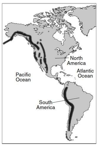
the map below shows dark bands that indicate long mountain ranges on the west coa...

Geography, 03.11.2019 15:31 copelandgarret9972
Asap!
the map below shows dark bands that indicate long mountain ranges on the west coasts of north america and south america. name the type of boundary and explain how tectonic plates interact at this type of boundary to create mountains.

Answers: 3
Another question on Geography
Geography, 22.06.2019 19:00
Which statements about wells are true? check all that apply. a) wells bring groundwater from the unsaturated zone to the surface of the water. b) wells need to be drilled below the water table. c) if water is pumped from a well too quicky, the well may run dry. d) water from wells is generally not safe to drink. e) water gushes from artesian wells due to pressure.
Answers: 2
Geography, 23.06.2019 08:30
When geographers describe how two places are related to each other spatially, they are describing a. where the places are located in relation to one another b. what kinds of natural environments are around each place c. how each place is changing over time d. what kinds of cultures are in each place
Answers: 1
Geography, 23.06.2019 18:40
Hurry! according to the map above, there are major types of natural resources in india. a. 4 b.5 c.10 d.16
Answers: 2
Geography, 24.06.2019 04:50
The caste system in india was used for what purpose? a) to ensure that all people had an adequate income b) to prevent the rich from taking too much power c) to provide social control and conformity according to one’s birth d) to draft a military capable of defending india from mongol invasion
Answers: 1
You know the right answer?
Questions


Physics, 29.06.2019 09:10
English, 29.06.2019 09:10
Mathematics, 29.06.2019 09:10
English, 29.06.2019 09:10


History, 29.06.2019 09:10


