
History, 20.11.2020 20:10 ayshearouse1203
Compare maps of the world in ancient times with current political maps.
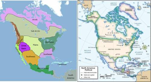
First image. Map of North America showing the regions in which Native American tribes lived in ancient times. The Arctic and sub-Arctic are at the top of the continent, respectively. On the west coast, California and the Northwest region are labeled. Slightly interior to the west coast are the Plateau region and the Great Basin. Beneath and east of the Great Basin is the Southwest, which borders the Plains to its East and Mesoamerica to the south. South America is labeled, to the southeast of Mesoamerica. The Plains takes up a large portion of central North America. The Northeast and Southeast also are labeled, east of the Plains and extending to the Atlantic coast. The Caribbean islands are seen off the Southeast coast. Second image. Political map of North and Central America. The United States appears in between Canada to the north and Mexico to the south. Alaska is seen as a peninsula off of western Canada. In the United States, the cities of Seattle on the northwest coast, San Francisco and Los Angeles on central and south west coast, respectively, Phoenix in the southwest, Dallas and Houston in the central south, Chicago in the central plains area, Atlanta in the southwest, and Boston, New York, Philadelphia, and Washington D. C. in the northeast are labeled.
© 2012 The Exploration Company
Compare the two maps. In which of the following modern-day cities did the Southwest tribes live in? (4 points)
a
San Francisco
b
Seattle
c
Boston
d
Phoenix

Answers: 3
Another question on History
History, 21.06.2019 19:00
What did kublai khan learn from the chinese advisers he consulted?
Answers: 2
History, 22.06.2019 00:20
By the late 1930s, how were u.s. officials beginning to view japanese policies of expansion? a. they attempted to join forces with japan so as to increase u.s. territory. b. they warned them to stop expansionist actions or face potential u.s. intervention. c. they sent representatives to japan to work out territorial rights in a diplomatic fashion. d. they became fearful of their military power
Answers: 1
History, 22.06.2019 02:30
What kind of contact did christopher columbus and native americans initially have?
Answers: 1
You know the right answer?
Compare maps of the world in ancient times with current political maps.
First image. Map of North A...
Questions


English, 16.11.2020 22:20
English, 16.11.2020 22:20

Spanish, 16.11.2020 22:20
Mathematics, 16.11.2020 22:20

History, 16.11.2020 22:20
Health, 16.11.2020 22:20

Biology, 16.11.2020 22:20
Health, 16.11.2020 22:20

Physics, 16.11.2020 22:20
History, 16.11.2020 22:20


